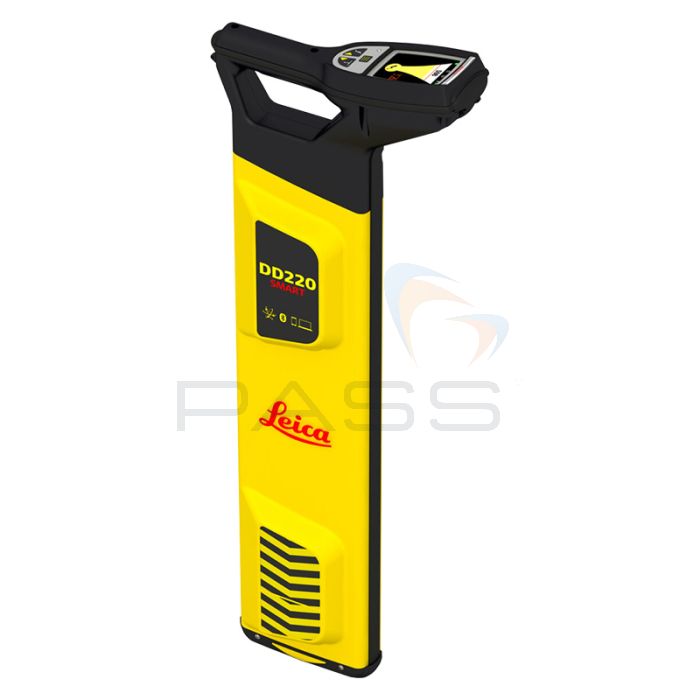
Leica DD220 Smart Utility Locator 7m Depth

- Easy-to-use tracing system
- Intuitive hardware and software
- Usage alerts and system diagnostics
The Leica DD SMART utility locator series uses industry-leading digital signal processing to identify underground assets deeper, faster, and more accurately than any other system. Using smart technology, the Leica DD SMART series can record all site usage activities enabling managed safety regimes to flourish.
Mapping buried utilities, and protecting your assets, personnel, and buried utilities has never been more simple with the onboard software. Transfer user logs and data via a hosted service for multiple users, across multiple sites to promote smart activities and smart safety.
The Leica DD SMART utility locators and DX Shield software open the door to a connected world, anywhere, anytime. The Leica DD SMART utility locators incorporate automatic gain features enabling the identification of assets deeper, faster, and more accurately. Understand site activity and utility locator use in greater detail with DX Shield software.
The DD220 SMART locator is scalable and designed with the latest Bluetooth technology, providing a wireless connection to field controllers and mobile devices. Connect and download data stored in the DD SMART utility locators' internal memory, including GPS positioning, and transfer back to the office.
USB connectivity provides a convenient connection to DX Office Shield software for data download, analysis, and product maintenance, including calibration. Leica DD SMART utility locators and DX Shield software provide a true single-source solution for all your field activities.
The DX Field Shield app provides operators with a remote transfer tool, linking data from the site to DX Office Shield or DX Manager Shield hosted service.
Key Features
- With usage alerts and system diagnostics, assets and site workers are protected
- Easy to use and learn with onboard video support
- Intuitive hardware and software significantly reduce errors
- On board locate alerts and an automatic locate process, the DD SMART locators
- Help to reduce time spent locating buried utilities and prevent utility damage
- Easy-to-use tracing system that delivers high-accuracy results without complication
- Trace utilities with confidence in environments with high utility density and complexity
- Locate utilities accurately with simple workflows using the latest digital technology
What's Included?
- DD220 Smart utility locator
- Three year warranty
- Li-Ion battery pack
- A100 charger
- A140 - car adapter cable
Call 01642 931 329 or complete the form:
| Power | 50 / 60 Hz mains electrical and harmonics |
|---|---|
| Radio | 15kHz to 60kHz |
| Auto | Power, Radio, 33kHz |
| Transmitter Modes | 131.072 (131) kHz 32.768 (33) kHz 8.192 (8) kHz |
| Depth Range | Line 0.1m to 5m Line 4 inches to 16.4 feet Sonde 0.1m to 7m Sonde 4 inches to 23 feet |
| Depth Accuracy* | 5% |
| Bluetooth | Class 2 BLE dual-mode module Bluetooth Classic 2.1 Bluetooth 4.0 (LE) |
| GPS** | Chipset (1): u-blox®GPS Receiver Type: GPS L1C/A, SBAS L1C/A, QZSS L1C/A, GLONASS L1OF, BeiDou B1 Accuracy (2): Horizontal Position 2.5 m Autonomous, 2.0 m SBAS, CEP Start time: Cold 45 s typical, Aided 7 s typical, Hot 1 s typical |
| Memory Capacity | 8 GB internal memory |
| Environmental Standard | IP65 |
| Operating Temperature | -20 °C to +50 °C -4 °F to +122°F |
| Battery | 7.4V Rechargeable Li - Ion |
| Battery Operating Time *** | 15 hours |
| Dimensions (HxWxD) | 765x290 x93mm 30.12 x11.42x3.66 inches |
| Weight with Batteries | 2.7Kg 5.95 lbs |
| *Depth to an undistorted signal ** (1) All data/information according to manufacturer u-blox®GPS; Leica Geosystems does not assume any liability whatsoever for such information. (2) Accuracy is dependent upon various factors including atmospheric conditions, multipath, obstructions, signal geometry, and number of tracked satellites. *** Constant use at 20°C/68°F |
|


